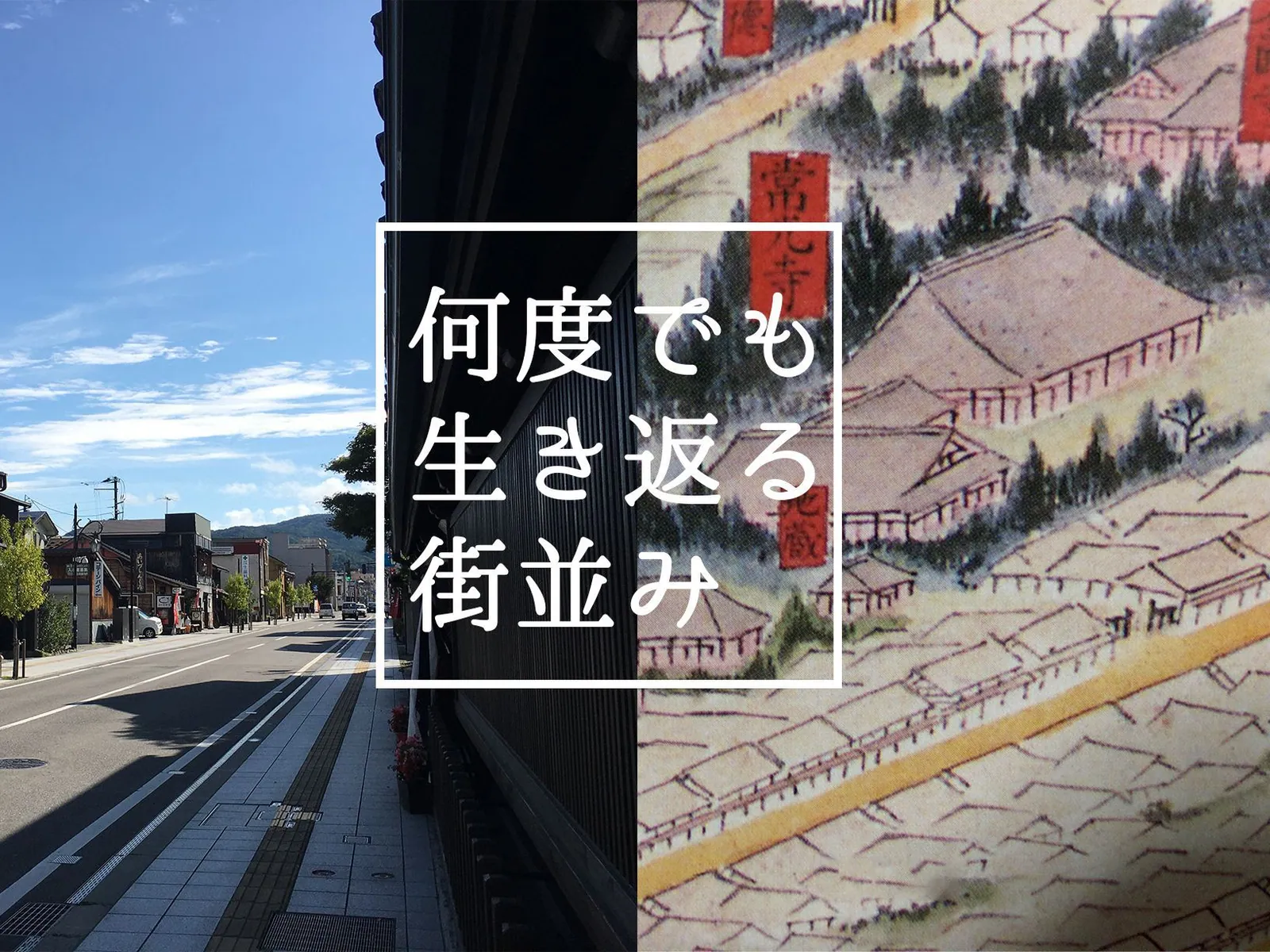
History of Nanukamachi-dori Street







Highlights
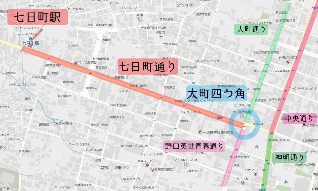
Nanukamachi-dori is the street that runs west from "Omachi Yotsukado" intersection to "Nanukamachi Station."
The nearby "Shinmei-dori" extends southward (toward the bottom of the map) and leads to Tsuruga Castle (Aizuwakamatsu Castle).
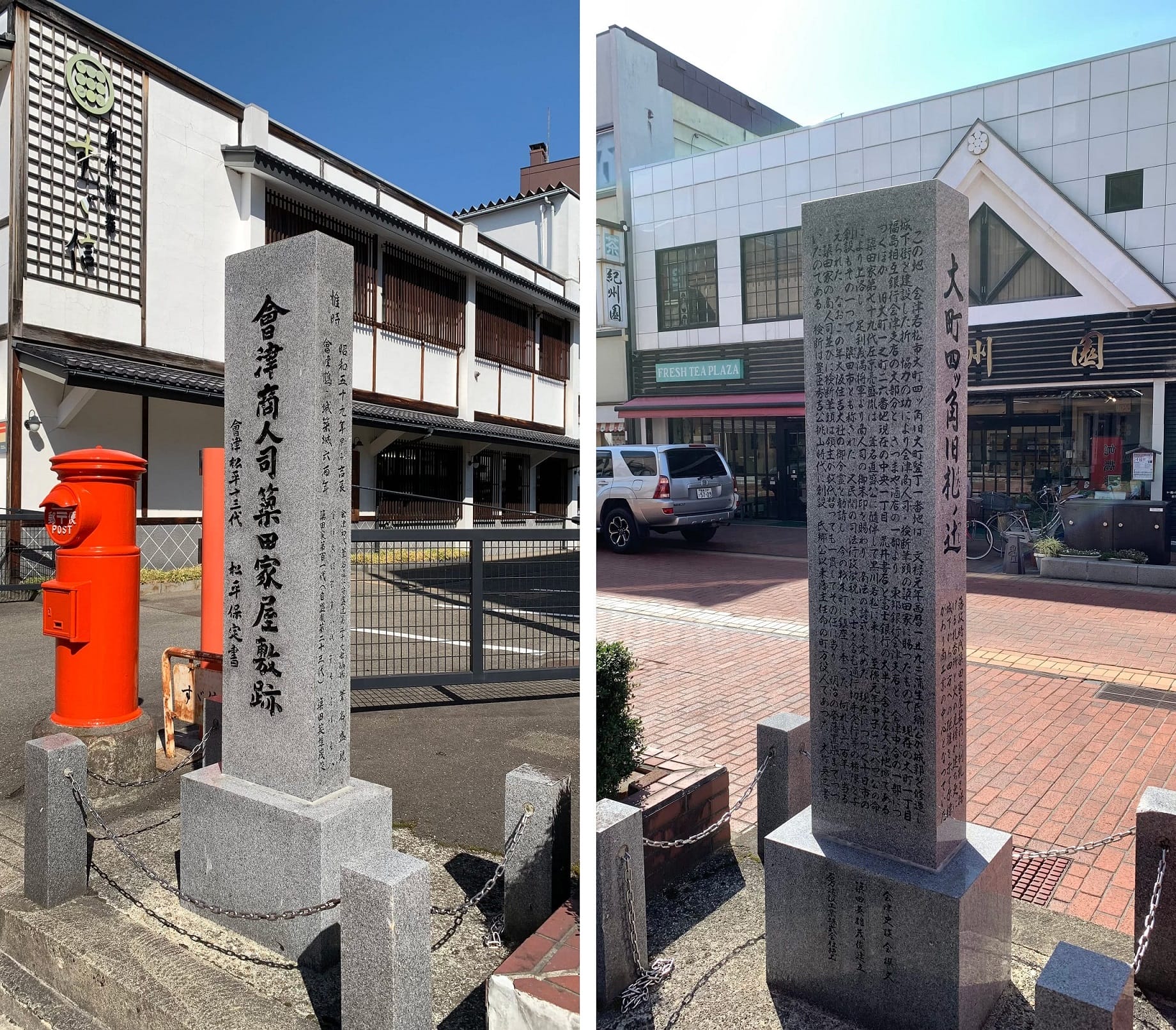 Front and back of a stone monument near Omachi Yotsukado. The front reads 'Site of the Yanada Merchant Household, Aizu Merchant Administrator. 13th generation of Aizu Matsudaira, Matsudaira Yasusada.' The back bears an explanation.
It connected to the five Aizu highways: the Shirakawa Highway (a route from Wakamatsu along the southern shore of Lake Inawashiro to Shirakawa), the Nikko Shimotsuke Highway (the shortest route to Edo passing through Nikko), the Yonezawa Highway (a route toward Yonezawa and Yamagata), the Echigo Highway (a route toward Niigata), and the Nihonmatsu Highway (a route from Wakamatsu via the northern or southern shore of Lake Inawashiro to Nihonmatsu). It was a vital junction for travelers, horses, and goods.
Because Omachi Yotsukado saw heavy foot traffic, it also served as a notice board site (a place where orders from the domain lord and magistrates were posted to reach throughout the territory), and was known as "Omachi Fuda no Tsuji."Furthermore, as an important hub, the Yanada household of magistrates (officials overseeing police and judicial affairs) maintained their residence at the southeast corner, while the Kurata household's magistrate residence stood at the northeast corner.
Today, a stone monument inscribed "Site of the Yanada Merchant Household, Aizu Merchant Administrator" stands near Omachi Yotsukado, recording this history.
This land, at the former Omachi Katacho 1-banchi, Omachi Yotsukado, Aizuwakamatsu City, was granted in Buroku 1 (1593) to the Yanada household, chief among Aizu merchant administrators, in recognition of their cooperation when Gamo Ujisato repaired the castle and built the castle town. It extends over a vast area including most of present-day Omachi 1-chome, the site of the Fukushima Mutual Bank Aizu Branch, part of Satsumaya Liquor Store, the Toho Bank Aizu Branch, and part of Aizu Nakago, as well as the former Omachi 1-no-cho 26-banchi, now Chuo 1-chome, including most of Arai Bookstore and Fuji Bank.The 79th head of the Yanada family, Sakyo-no-suke Morotane, came to Kurokawa (Wakamatsu) accompanying Ashina Naomori, and in Shitoku 1 (1384), by the lord's command, traveled to the capital and received a official seal (goshuin) from Shogun Ashikaga Yoshimitsu, establishing commercial regulations.The creation of the Tokaichi market, which continues today, was one of these regulations; it was also called Yanada Market. The household was granted authority over civilian judicial administration, tax collection, and issuance of travel permits including for samurai.In this same year, they enshrined a divided spirit of Osaka Sumiyoshi Taisha in present-day Zaiku-machi. For 600 years, the Yanada household served as merchant administrator and chief magistrate, continuing in these roles even as lords changed over generations, until the abolition of the domains in the Meiji period.The magistrate system was established during Toyotomi Hideyoshi's Momoyama period, and since Ujisato, the town officials were appointed by the domain lord. From Eiju Takei's writings
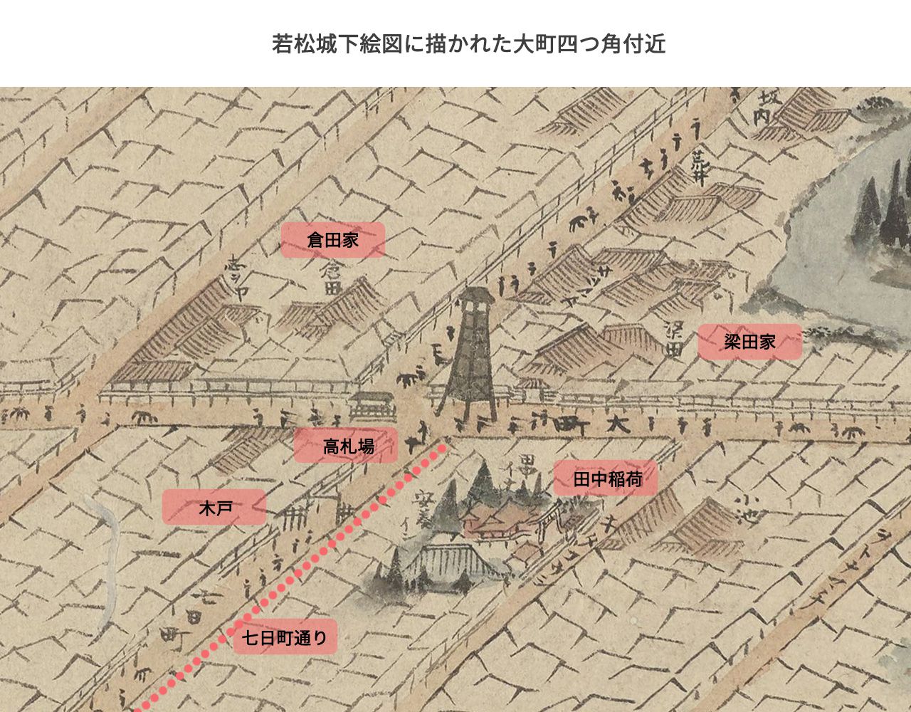 A portion of the Wakamatsu Castle Town Map painted by Osuga Seiko*1 in the late Edo period. Depicts the area around Omachi Yotsukado.
The Yanada and Kurata residences stand on either side of the notice board. The location of Tanaka Inari, visited during the Tokaichi market, can also be seen. The eastern end of present-day Nanukamachi-dori is also identified as Omachi Yotsukado.
*1 Osuga Seiko. April 1809 - June 17, 1875.
A town artist active in the late Edo period. A wealthy merchant who loved Aizu and left many works depicting the region.
New Year Ceremonies and the Origin of the Name "Nanukamachi"
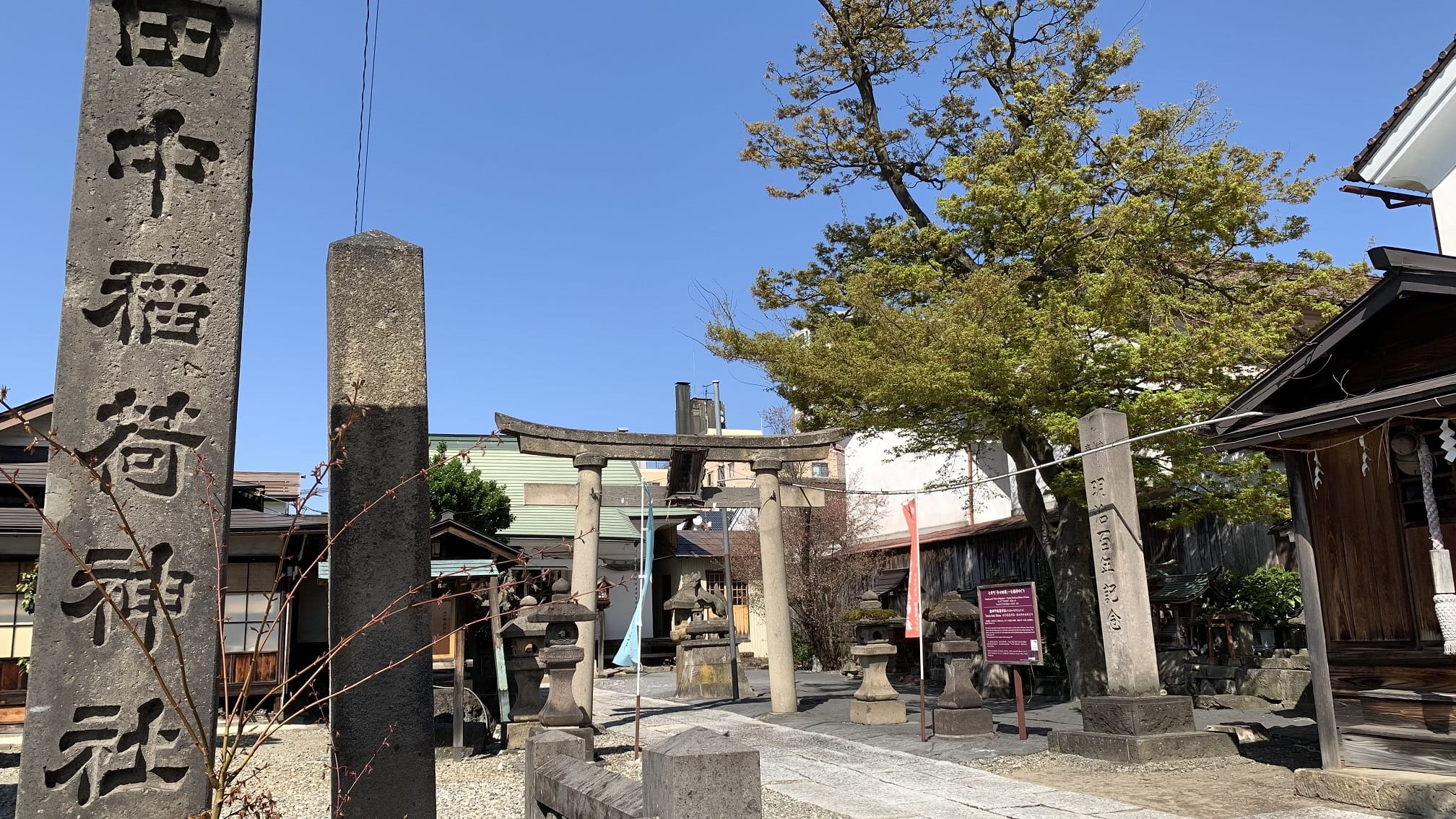 Present-day Tanaka Inari Shrine.
Afterward, the "Tokaichi" (first market of the year) was held. During Tokaichi, people would purchase daily necessities, worship at Tanaka Inari Shrine (1-1 Omachi, Aizuwakamatsu City, Fukushima Prefecture), known as the god of markets, and buy rice as a customary observance.
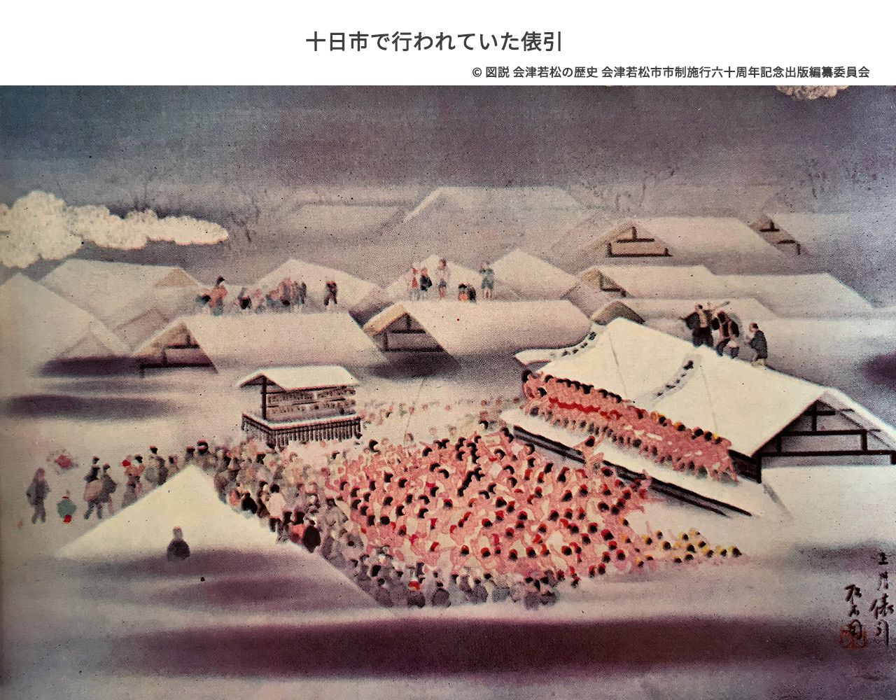 The barrel pulling ceremony held at the beginning of the year's first market (the 10th day after New Year's). People can be seen on the Kurata roof, and traces of barrels rolling on snow are visible.
In the center of the street, the notice board at Omachi Fuda no Tsuji is depicted.
nanukamachi.com digital archive: Aizu Events
Beginning with this Tokaichi market, markets were held on designated days of each month in various towns.
Near Nanukamachi, markets were held on the 7th of each month, and so the area came to be called "Nanukamachi" (Seventh Day Town).
Later, Rokusaichi markets (regular markets held six times a month, based on Buddhist fasting days) were established throughout the Aizu Domain, and the markets at Nanukamachi also evolved into Rokusaichi markets. The Yanada household, serving as merchant administrator and magistrate, presided over and supervised these markets.
The year after Hoshina Masayuki entered Aizu as domain lord, in Shoho 1 (1644), Nanukamachi was designated, along with Bakuro-machi as a tenma-machi (a town responsible for horses, the primary transportation of the era). In Hoei 4 (1707), "umasashi" (horse arrangers) were appointed to organize horses and personnel.
Reconstructing Nanukamachi from Historical SourcesSeveral historical sources concerning Nanukamachi have survived, which together allow us to reconstruct the townscape of the era.
Sources on NanukamachiThe main surviving sources regarding the Nanukamachi townscape are as follows:
- Shinpen Aizu Fudoki (New Aizu Gazetteer): Kyowa 3 (1803) to Bunka 6 (1809)
- Wakamatsu Fuzoku-cho (Record of Wakamatsu Customs): Bunka 4 (1807)
- Land registers, land maps, and survey records: circa Meiji 7-8 (1873-1874) to circa Meiji 13 (1880)
- Residence directory, Wakamatsu Gonomachi-gumi division: Meiji 3 (1870)
- Residence register, Iwashiro Province Wakamatsu: Meiji 3 (1870)
- Household registration, Gonomachi-gumi division, Iwashiro Province Wakamatsu: Meiji 3 (1870)
- Servant registry, Iwashiro Province Wakamatsu Gonomachi-gumi: Meiji 3 (1870)
The "Shinpen Aizu Fudoki" (New Aizu Gazetteer) was compiled from Kyowa 3 (1803) to Bunka 6 (1809).
The original "Aizu Fudoki" was completed in Kanbun 6 (1666) under the name of Aizu Domain lord Hoshina Masayuki, but the "Shinpen Aizu Fudoki" was a new edition supplemented with additional information.
"Shinpen Aizu Fudoki, Volume 19, Wakamatsu 5, Shimomachi" describes Nanukamachi-dori as follows:
Nanukamachi (Nanuka)
Located north of Kitakoji-machi, this is a highway running west from Omachi Fuda no Tsuji, connecting to Echigo and Dewa provinces.
Many lodging houses. Length: 7 cho 16 ken, width: 4 ken. 149 houses. To the west, civilian houses of the Ogurokawa area continue, called Nanukamachi Yotsuya. Length: 1 cho 12 ken, width: approximately 3 ken, 20 houses (this is Ogurokawa territory).
From the end of town, 8 cho 1 ken to Takaku-gumi Takase Village boundary.
There is also a path from the end of town leading to Kitakoji-machi.
[Shinpen Aizu Fudoki, Volume 19, Wakamatsu 5, Shimomachi]
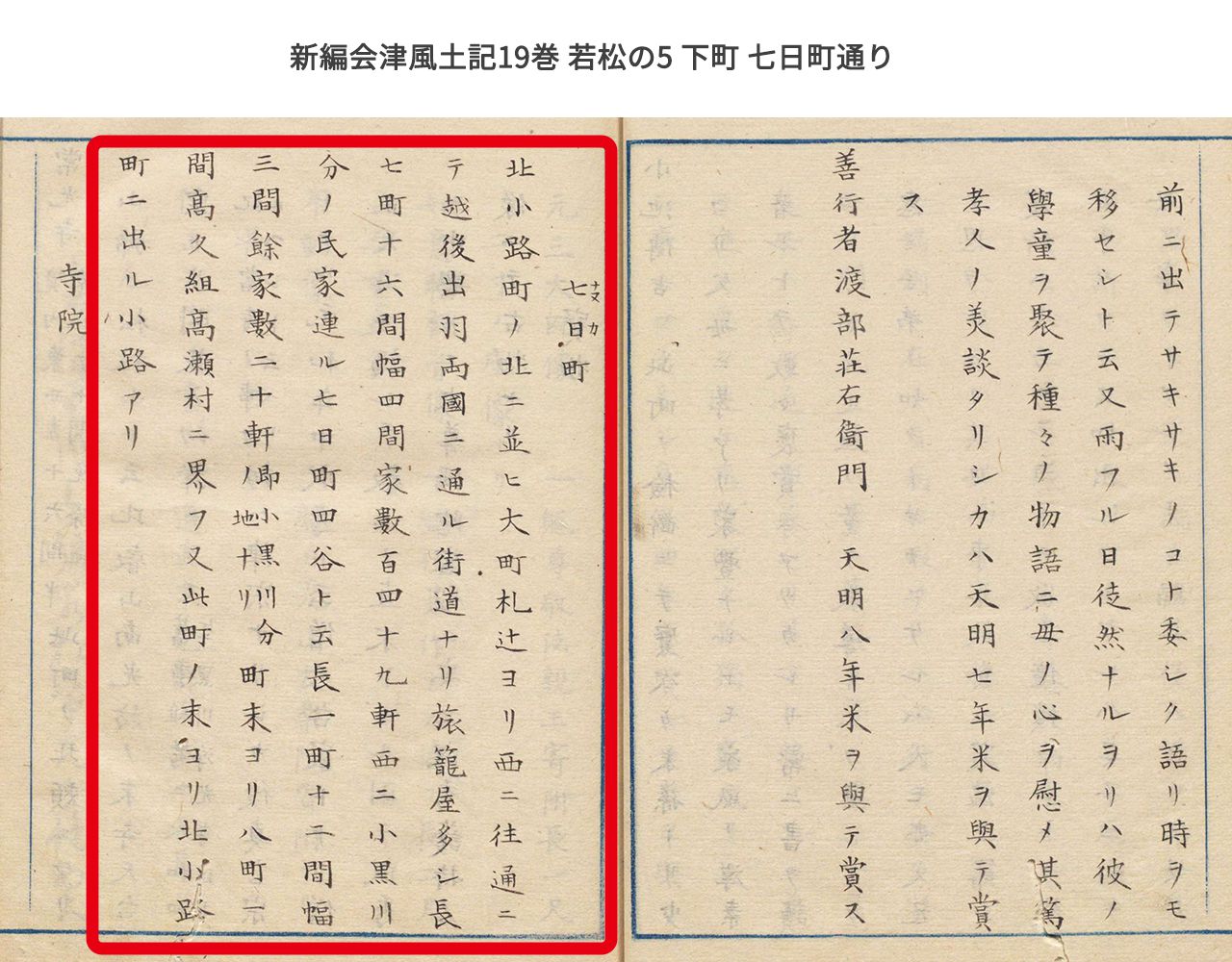 Located north of Kitakoji-machi, this is a highway running west from Omachi Fuda no Tsuji (present-day Omachi Yotsukado), connecting to Echigo and Dewa provinces (present-day Niigata and Yamagata Prefectures).
Many lodging houses (modern inns and hotels).
Length: 7 cho 16 ken (1 ken equals 1.8 meters, 1 cho equals 60 ken or about 109 meters, so 7 cho 16 ken is approximately 792 meters).
Width: 4 ken (approximately 7.2 meters).
Number of houses: 149.
To the west, civilian houses of the Ogurokawa area (regional name) continue, called Nanukamachi Yotsuya. Length: 1 cho 12 ken (approximately 130 meters). Number of houses: 20.
At a distance of 8 cho 1 ken (874 meters) from the end of town lies Takaku-gumi Takase Village (regional name).
There is also a path from the end of town leading to Kitakoji-machi.
The "Wakamatsu Fuzoku-cho" also records the state of Nanukamachi around the Bunka era (1804-1818).
Nanukamachi is an area of 49 houses.
Merchants reside here. It is a town on the highway to various provinces, with lodging houses and the like. From the eastern Omachi gate to the western end of town gate: 364.5 ken.
[Wakamatsu Fuzoku-cho]
In Meiji 6 (1873), with the land tax reform (which officially recognized private land ownership and required tax payment in cash), land maps were drawn to clarify property boundaries. During this land tax reform, for Wakamatsu Town (present-day Aizuwakamatsu City), including Nanukamachi, 7 land registers, 8 land maps, and 4 survey records were submitted to the prefecture. These field investigations are believed to have been conducted from around Meiji 7-8 (1873-1874) to around Meiji 13 (1880).
Land maps were also created for Nanukamachi-dori, revealing property boundaries and the street's layout at that time.Furthermore, because Nanukamachi escaped destruction in the Boshin War, the Edo-period boundaries were preserved as they were. In other words, the Meiji land tax reform maps allow us to estimate the earlier Edo-period boundaries as well.
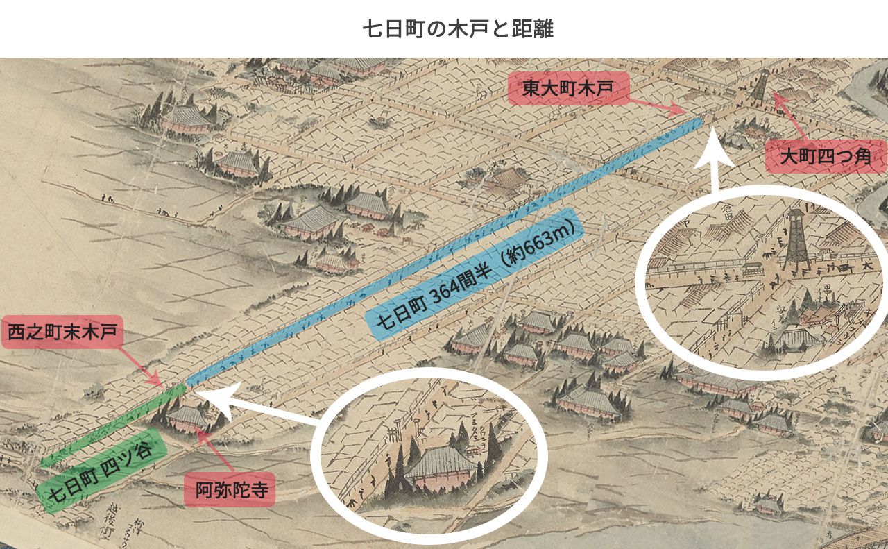 Nanukamachi as depicted in Osuga Seiko's "Wakamatsu Castle Town Map." The relative positions of Omachi Yotsukado, the eastern and western barrier gates, Amida-ji Temple, and other landmarks can be discerned.
Around Meiji 3 (1870), Nanukamachi was divided into squads 35, 37, 38, and part of squad 40 (Nanukamachi Yotsuya).
Looking at squads 37 and 38, the "residence directory" and "land map" are recorded at the same scale of 600:1. This means that 1 ken (approximately 1.82m) in reality was represented as 1 bu (approximately 3.03mm) on the map.
Width and Length of NanukamachiBased on these, measurements on the maps show that the road widths extending in various directions from Nanukamachi-dori are depicted as either 4 ken (approximately 7.2m) or 2 ken (approximately 3.6m) in both the "survey records" and "land maps." On the other hand, regarding the width of Nanukamachi-dori itself, the "survey records" show 4 ken (approximately 7.2m) while the "land maps" show 5 ken (9.9m), revealing a discrepancy.
Regarding the length (distance) of Nanukamachi-dori, records remain of the distance from the western "Nishinomachi-sue Kido" (western end-of-town barrier gate) to the "Higashi-Omachi Kido" (eastern Omachi barrier gate) just before Omachi Yotsukado.
According to the "Kaei Anna Sei Memorandum," the Nishinomachi-sue Kido was located near the eastern boundary of Amida-ji Temple. The "Nanukamachi Residential Map" and "land maps" confirm that directly east of Amida-ji Temple there was land belonging to the ban-ya (guardhouse, an organization above each town squad), where ban-nin koya (guard huts) were built, thus proving that the Nanukamachi barrier gate was located there.
Based on this information, measuring the distance from Nishinomachi-sue Kido to Higashi-Omachi Kido on the maps yields an actual distance of 364.5 ken (approximately 663m). This distance also matches the entry in the "Wakamatsu Fuzoku-cho" stating "to the end-of-town gate, 364.5 ken."
Furthermore, the land maps show that a ditch 3 shaku 5 sun (approximately 1.05m) wide ran through the center of the road. This ditch was shifted to the south side of the road just before "Nishinomachi-sue Kido," and became a side gutter on the Nanukamachi Yotsuya road.
The Area Called NanukamachiAt that time, the area between "Nishinomachi-sue Kido" and "Higashi-Omachi Kido" was called "Nanukamachi." The street west of "Nishinomachi-sue Kido" was called "Nanukamachi Yotsuya."
These designations changed over time, and whether "Nanukamachi-dori" referred to the area between the gates or included areas outside them became ambiguous in each era.
The timber for constructing these barrier gates was supplied by the Aizu Domain, while the labor for actual construction was borne by each town.
The gates, thus installed, were closed at dusk every day, cutting off traffic. Additionally, passage within the town required carrying a lantern after 6 PM.
Bustle in the Edo PeriodNanukamachi-dori was a transportation hub and a street where many people came and went.
The Bunka 4 (1807) "Wakamatsu Fuzoku-cho" describes Nanukamachi-dori as: "Merchants reside here. It is a town on the highway to various provinces, with lodging houses and the like," indicating it was a town of lodgings and merchants at a transportation hub.
The Hoka 2 (1845) "Hatago Stock Register" records that of the 95 lodging houses in the Aizuwakamatsu castle town, 30 were on Nanukamachi-dori.
According to the Meiji 1 (1868) "Merchant Stock Census," there were 33 lodging houses on Nanukamachi-dori, indicating sustained prosperity over a long period.
The prosperity of Nanukamachi can also be seen from the "Wakamatsu Midori Komei Go-fukutsui" (Aizu Rankings) of Kaei 5 (1852).
It lists many shops located in Nanukamachi.
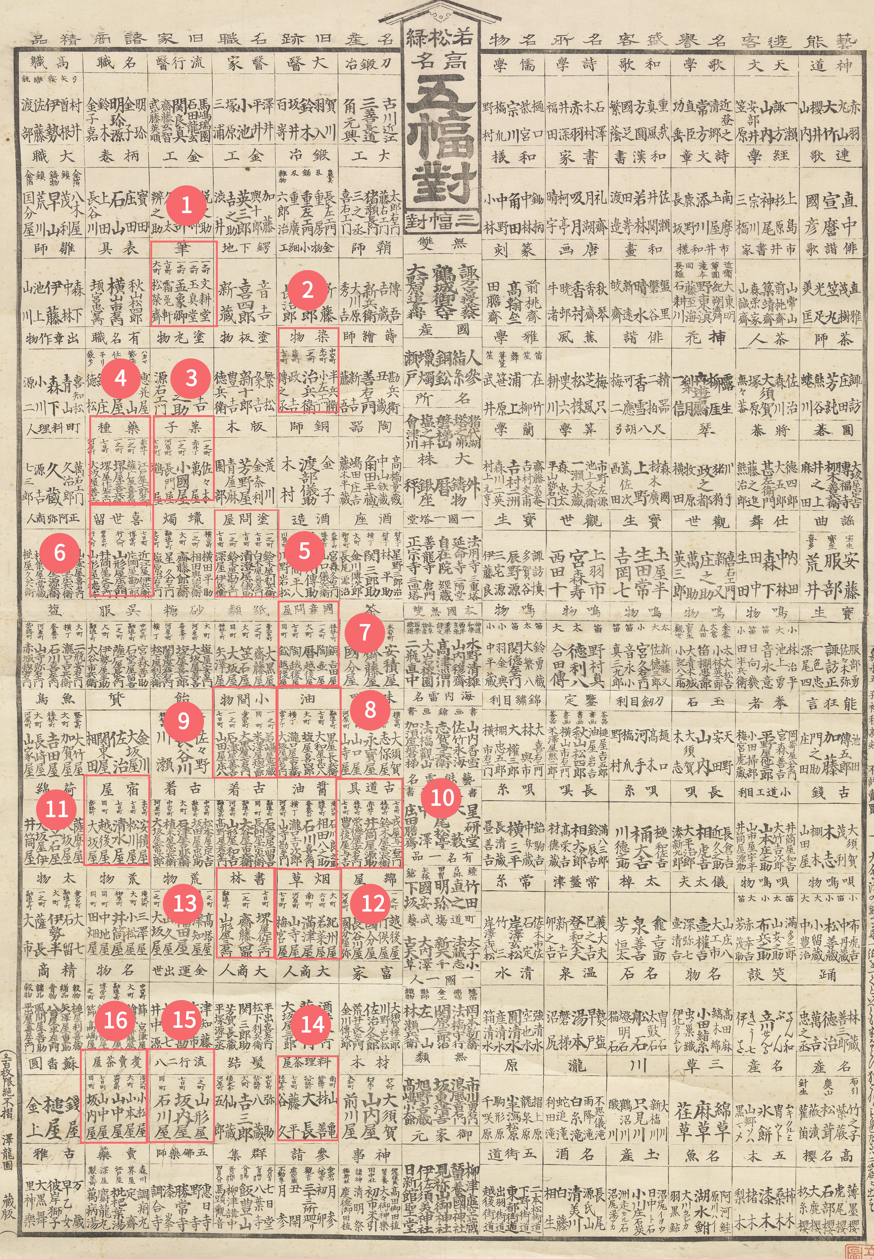 Select image to enlarge.
01. Brushes: Shomenken
02. Dyed goods: Dennojo
03. Confections: Tsuruya
04. Medicinal herbs: Sakaya Kiemon
05. Lacquerware wholesalers: Shirokiya Kiemon, Seicho-ya Gibe, Fukaya Ibee
06. Smoking pipes: Omeya Ibee
07. Ceramics wholesaler: Sue, Echigo-ya
08. Oil: Yamatoya Jimpachi
09. Sundries: Yamadaya Shohachi
10. Secondhand goods: Bungo-ya Yokichi
11. Lodging: Shimizuya (Shimizuya Ryokan Ruins), Matsukawa-ya
12. Tobacco: Umeyama-ya
13. Books: Sakaya Sakuzaemon
14. Cuisine tea house: Fujihei
15. Trendy soba: Sakana-ya, Ishikawa-ya
16. Cooked food tea house: Yamanaka-ya, Sakana-ya
Uprising at Nanukamachi GateDuring the Edo period, the gates of Nanukamachi were also the stage for historic conflicts.
In the 12th month of Kanyo 2 (1749), the largest peasant uprising in Aizu Domain history occurred.
Known as the Kanyo Uprising, farmers who had risen in what is now Inawashiro gathered people from surrounding villages, and ultimately 20,000 people converged on the Nanukamachi gate.
The cause of the uprising was unfavorable repayment terms for borrowed rice, but it is also said that heavy land taxes despite consecutive crop failures contributed to the unrest.
The uprising forces and Aizu Domain soldiers faced each other with the gate as the boundary, but the uprising forces broke through the gate and entered. At that point, Aizu Domain soldiers opened fire, causing many casualties.
The domain soldiers' gunfire caused the uprising forces to falter and temporarily retreat.
However, while fighting continued at Nanukamachi, uprising forces were approaching the castle from other castle entrance gates.
Faced with this situation, the Aizu Domain finally promised to halve the land tax and provide rice loans, and the uprising gradually subsided.
However, in reality, the tax relief was limited only to the destitute, and furthermore, the uprising leaders were executed.
The End of the Edo Period and Transportation Development in the Meiji PeriodAs the Tokugawa era ended, the Boshin War left tragic scars on Aizu.Aizu domain samurai who died in the Boshin War were permitted burial at Amida-ji Temple, making Nanukamachi a stage for turbulent history.
Looking at photographs of Nanukamachi-dori taken in the early Meiji period, we can see that Aizuwakamatsu after the Boshin War, including Nanukamachi-dori which flourished as a transportation hub, still maintained a modest way of life.
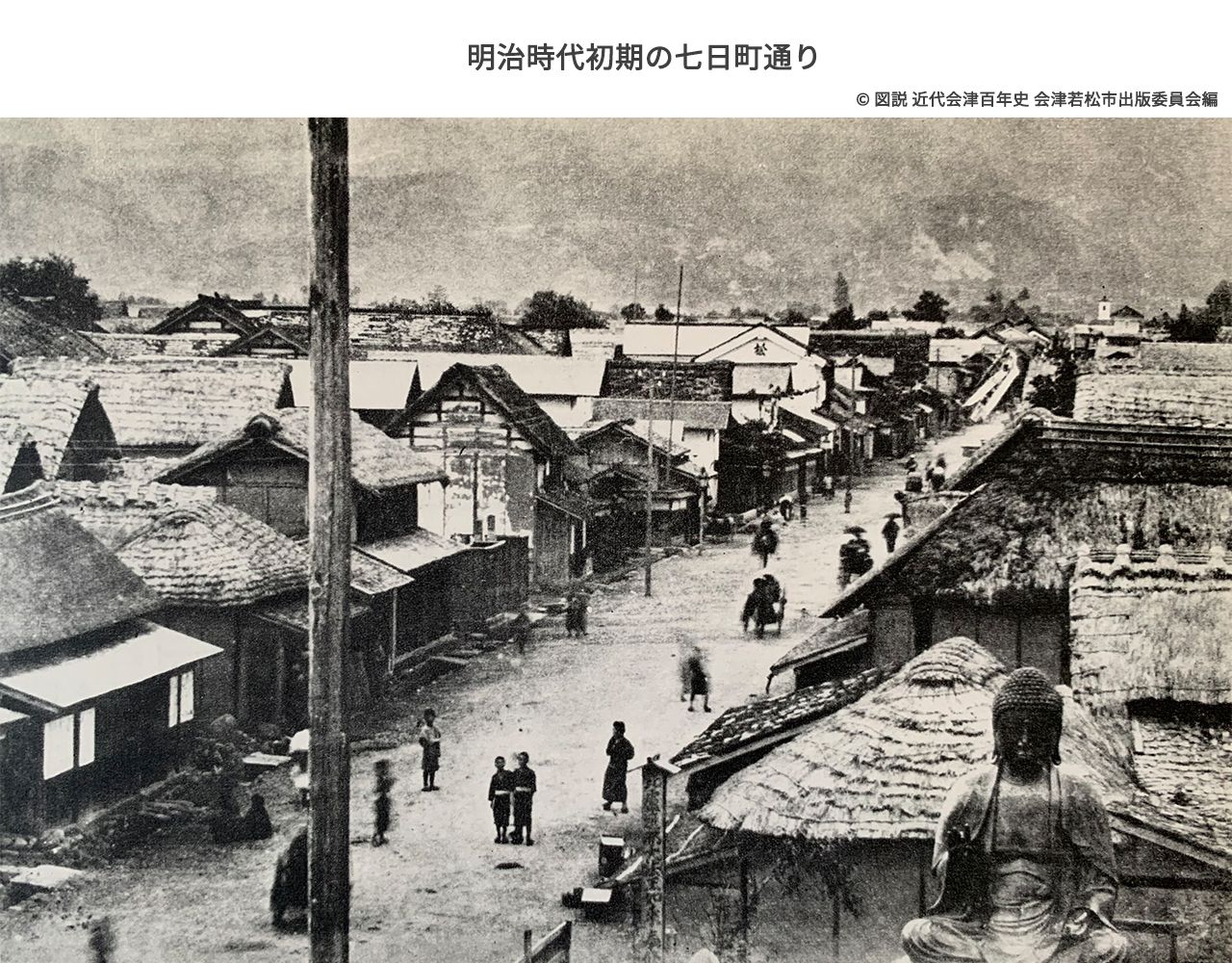 Nanukamachi-dori in the early Meiji period. Photographed looking east (toward Higashiyama Onsen) from Amida-ji Temple. The Great Buddha, relocated due to the anti-Buddhist movement, is visible (for details on the Great Buddha, see the Amida-ji Temple page). Many thatched roofs can be seen.
Colorized using deep learning
Michitsune Mishima and the Aizu Sanpo RoadsThe Meiji period was also an era when Aizu's transportation further developed.
Michitsune Mishima, the governor of Fukushima Prefecture at the time, also known as the "Civil Engineering Governor," constructed trunk roads called the "Aizu Sanpo Roads."As the name "sanpo" (three directions) suggests, this was a major project to widen and improve roads from the Omachi Yotsukado intersection in Aizuwakamatsu in three directions: toward Niigata (Echigo Highway), toward Yonezawa (Yonezawa Highway), and toward Nikko (Nikko Highway).
The Aizu Sanpo Roads, which became the prototype for present-day national highways, began at Omachi Yotsukado, the starting point of Nanukamachi-dori.
To commemorate the Aizu Sanpo Roads, with groundbreaking on August 17, Meiji 15 (1882), completion in August Meiji 17 (1884), and the opening ceremony on October 27 of the same year, the "Aizu Shindo Monument" was erected at Omachi Yotsukado in August Meiji 19 (1886).
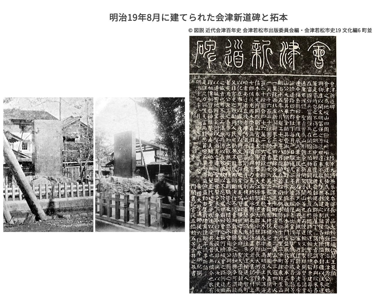 Rubbing of the Aizu Shindo Monument erected in August Meiji 19 (1886). Preserved at the Aizuwakamatsu City Aizu Library.
The inscription was composed by Tsunanori Nanma.
The seal script title was written by Prince Arisugawa Taruhito (royalty who built Tenkyokaku on the shores of Lake Inawashiro).
Details of the construction work recorded on the Aizu Shindo Monument:
Road lengths:
From Wakamatsu to the Tochigi Prefecture border: 16 ri 30 cho (approximately 68km)
From Wakamatsu to the Niigata Prefecture border: 24 ri (approximately 96km)
From Wakamatsu to the Yamagata Prefecture border: 11 ri (approximately 44km)
Total laborers: 825,340 persons
Substitute payments: 216,630 yen
Government subsidy: 160,680 yen
Land tax supplement: 10,000 yen
Donations: 75,320 yen
Total: 462,630 yen
Reference: Monthly starting salary for elementary school teachers and police officers in the Meiji period was approximately 9 yen. Monthly salary for skilled carpenters and factory technicians was approximately 20 yen.
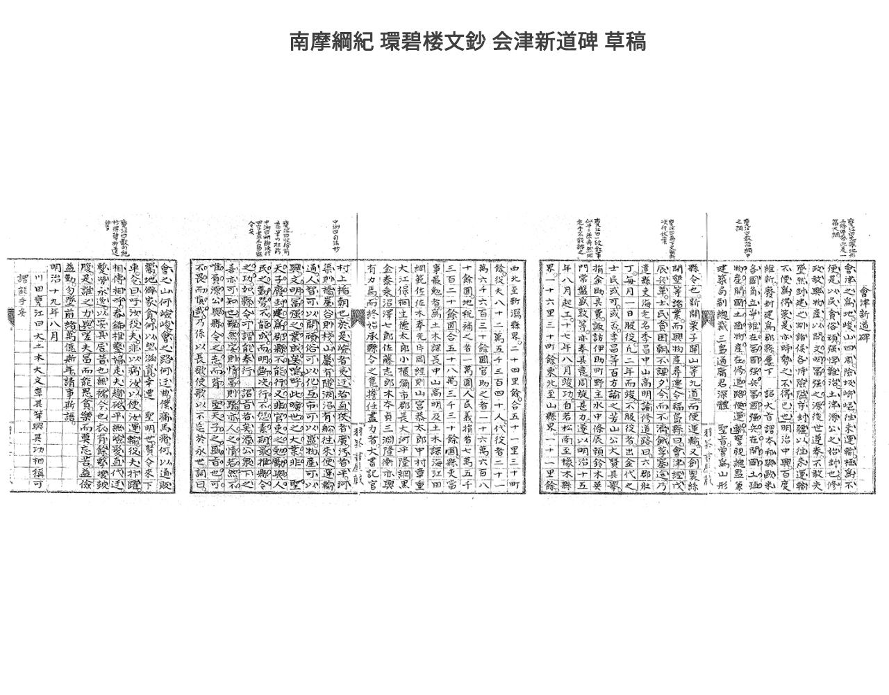 The draft of the Aizu Shindo Monument recorded by Tsunanori Nanma in Kanpekiro Bunsho.
Tsunanori Nanma was an Aizu domain samurai who also left achievements as an educator into the Meiji period.
National Diet Library Digital Collections
Where did the Aizu Shindo Monument go?
Today, only a small "Wakamatsu City Road Origin Marker" remains at Omachi Yotsukado, a remnant of its role as the starting point of the highways.
Regrettably, the "Aizu Shindo Monument" that was also erected at Omachi Yotsukado no longer survives.
This is because the Aizu Shindo Monument was made of copper and was requisitioned during World War II. Another item requisitioned from Nanukamachi-dori during the war was the Great Buddha of Amida-ji Temple.
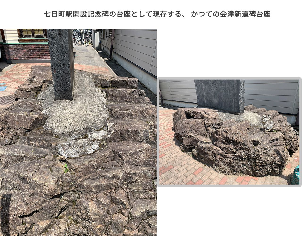
However, the "pedestal" of the Aizu Shindo Monument still survives. It was moved in front of Nanukamachi Station and remains as the pedestal for the "Nanukamachi Station Opening Monument," conveying the sentiments of those who preserved it.
Looking at the width and thickness of the extant pedestal reinforced with concrete, one can imagine the size of the Aizu Shindo Monument.
(Information on the whereabouts of the Aizu Shindo Monument was provided by the Fukushima Prefectural Museum.)
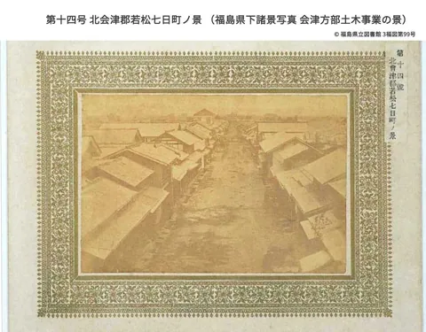
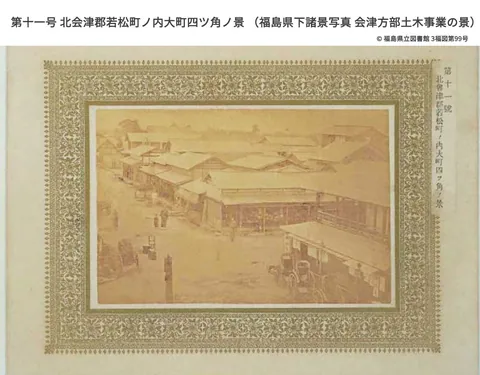
To record the achievements of the grand civil engineering project of the Aizu Sanpo Roads, Michitsune Mishima commissioned Shingaku Kikuchi (1832-1915, a Meiji-era photographer) to take photographs.
The photographs thus taken were compiled by Fukushima Prefecture and preserved as "Photographs of Scenes in Fukushima Prefecture: Aizu Region Civil Engineering Works."
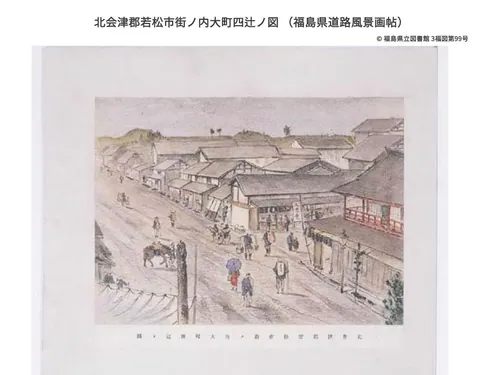
In addition to Kikuchi's photographs, landscape paintings commissioned from Yuichi Takahashi (1828-1894, a Western-style painter) are preserved as the "Fukushima Prefecture Road Landscape Album."
This album depicts landscapes along roads throughout Fukushima Prefecture at that time, including the Aizu Sanpo Roads, as well as scenes of large-scale construction work.
Yuichi Takahashi created the works by transferring light watercolor paintings drawn on lithographic stone to silk, then applying color. The "Fukushima Prefecture Road Landscape Album" consists of 53 such paintings mounted on a folding screen.
Shingaku Kikuchi. "No. 14: View of Wakamatsu Nanukamachi, North Aizu District" from "Photographs of Scenes in Fukushima Prefecture: Aizu Region Civil Engineering Works."
1880s, a valuable photograph of Nanukamachi-dori.
Fukushima Prefectural Library
Select thumbnail images below to change the image.
To commemorate this, Wakamatsu City held a grand 300th anniversary festival.
A memorial monument was erected at Omachi Yotsukado, and the town was filled with festive spirit.
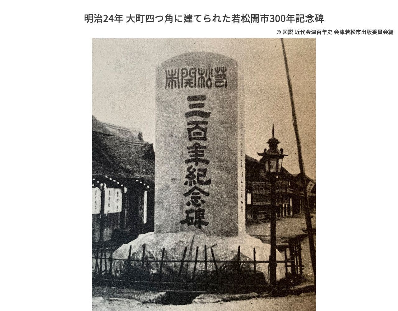 Wakamatsu's 300th anniversary monument erected at Omachi Yotsukado in Meiji 24 (1891). Looking at the base of the monument, a ditch can be seen running through the center of the street. Festive lanterns and flowers decorate the eaves. The thatched roofs suggest that despite being a town bustling with highway traffic, life remained modest.
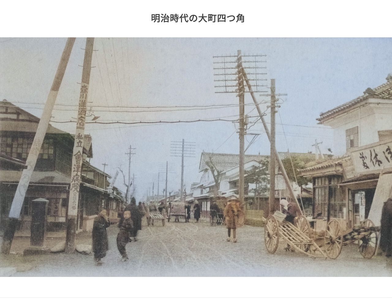 The Omachi Yotsukado area in the Meiji period. Behind the building on the right, across the street, a fence surrounding the Aizu Shindo Monument can be seen.
The building on the left corner is Furukawa Beef Shop.
Colorized using deep learning
nanukamachi.com digital archive: Wakamatsu City Omachi Station Street
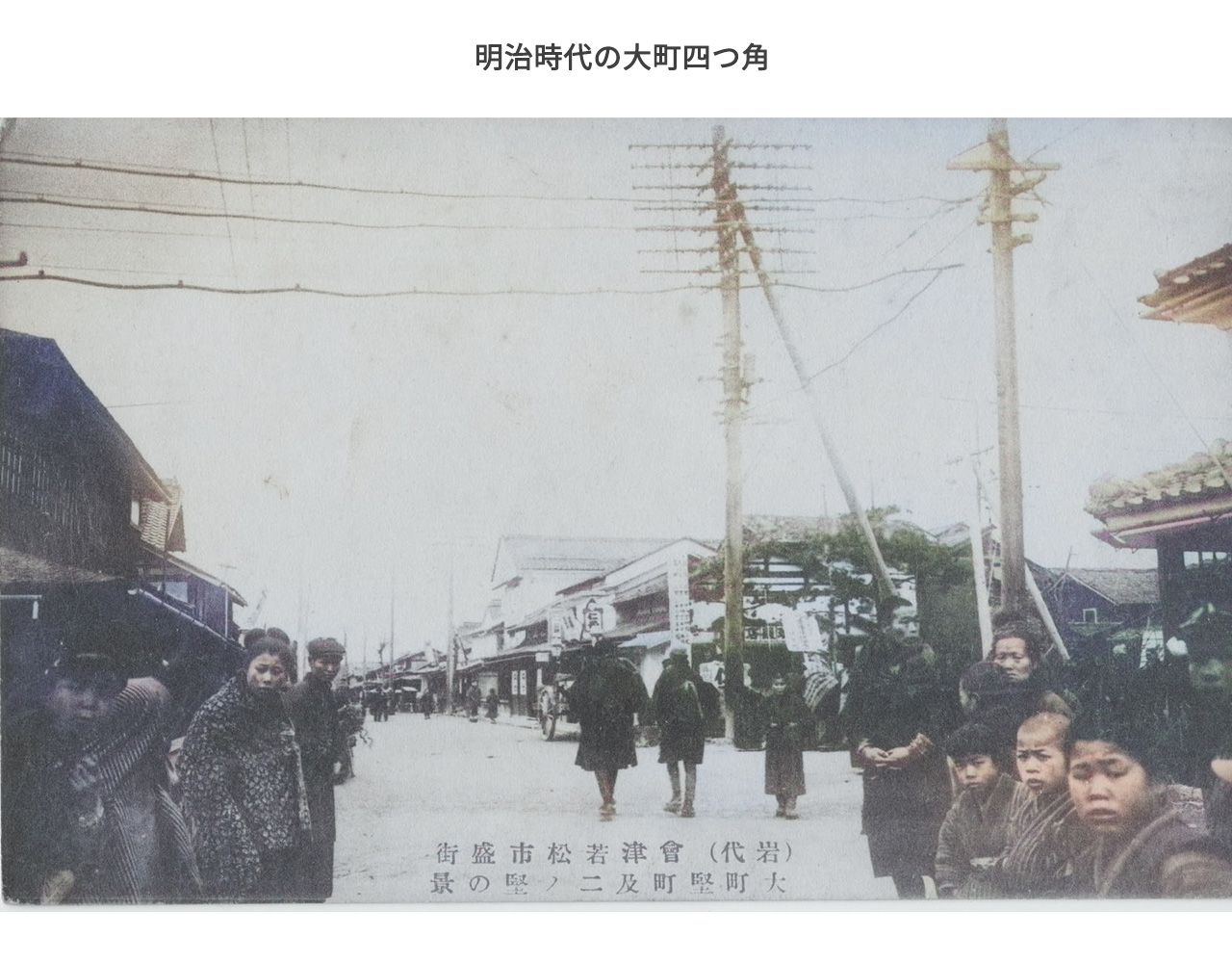 Photographed from the same angle as the above photo. People around are paying attention, perhaps because cameras were still a novelty.
Colorized using deep learning
nanukamachi.com digital archive: Iwashiro Aizuwakamatsu City Prosperous District: View of Omachi Katamachi and Ni-no-Katamachi
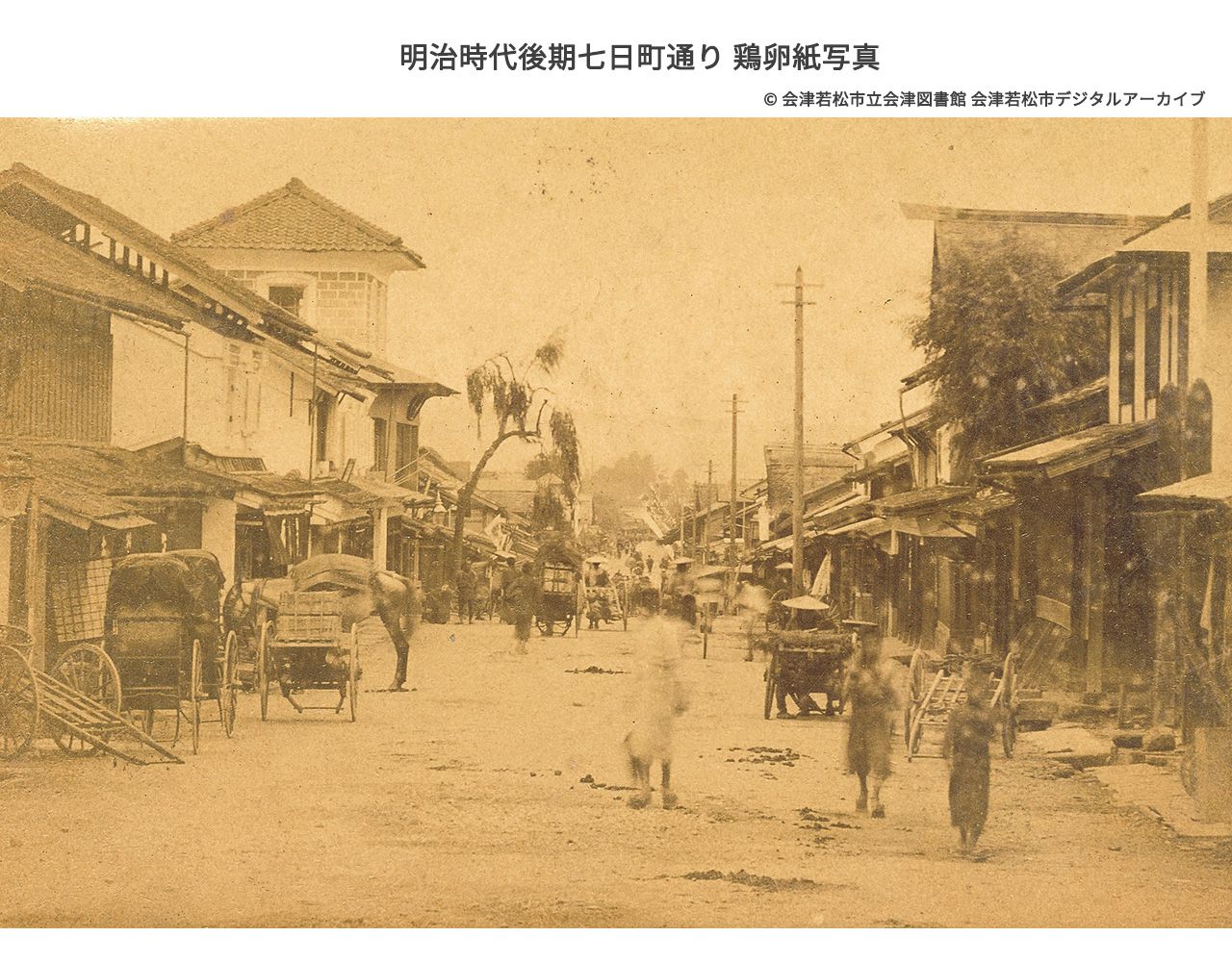 Nanukamachi-dori in the late Meiji period, albumen print (an old photographic technique). Photographed by Ioka, a photographer from Wakamatsu Sakae-machi.
Aizuwakamatsu City Aizu Library Collection, Aizuwakamatsu City Digital Archive
In the 1890s, lodging houses on Nanukamachi-dori expanded in scale, but their numbers decreased to six.
Records list the six lodging houses as: Kaizanro (Shimizuya Shinkichi), Kikuju-ro (Yamauchi Kiji), Kanto-ya (Koarai Tsuna), Masu-ya (Yamaguchi Shinkichi), Minoya Heijiro, and Uchida-ya.
Of the 11 kashizashiki (rented room) businesses and kappo (Japanese cuisine restaurants) in Wakamatsu City, nearly half were located on Nanukamachi-dori.
Names recorded include Yamada-ro, Banki-ro, Banju-tei, Kaku-yu-tei, Fuki-tei, and Bogaku-ro.
Among these, Yamada-ro hosted the founding celebration of the Aizu Liberal Party and preparatory meetings for the formation of the Imperial Rule Party, serving as a stage for political activity.
With the opening of the Aizu Sanpo Roads and the increasing flow of people and goods, the road on Nanukamachi-dori was also improved.
Transportation companies began operations in relation to this, and in December Meiji 20 (1887), the Wakamatsu branch office of "Naikoku Tsuun Company" (predecessor of present-day Nippon Express, a land and water transport company established by former stagecoach operators and receiving strong government protection throughout the early Meiji period) was established at Nanukamachi 198-banchi.
This was also the era when traffic with neighboring towns and villages became full-scale. Around Meiji 33 (1900), a passenger horse carriage service opened between Wakamatsu and Aizu-Bange, with its Wakamatsu starting point at Nanukamachi. It was also called "Tote Bashaa" from the sound of the driver's horn, and continued operations until around Taisho 15 (1926, Showa 1).
Cultural Development in the Taisho PeriodEntering the Taisho period, people's lives gained the leisure to enjoy entertainment. Culture such as theater and motion pictures came to Aizu, and people became enthusiastic about them.
A permanent theater was built near Joko-ji Temple on Nanukamachi-dori, a pleasure quarter was established nearby, and when the Japanese Army regiment was stationed in Aizuwakamatsu, Nanukamachi-dori became even more prosperous as Aizu's leading entertainment district.
It was also in this era that Western-style buildings were constructed, which continue to delight our eyes today.
After Wakamatsu Town was established as a municipality in April Meiji 22, Aizuwakamatsu became the first in Fukushima Prefecture to transition to city status in Meiji 31 (1898). Twenty-five years later, in Taisho 12 (1923), a three-day celebration was held to commemorate the 25th anniversary of city status.
A garden party was held at the site of Tsuruga Castle's main enclosure, and citizens paraded through town with food stalls and costumed processions, flowing to the garden party venue.
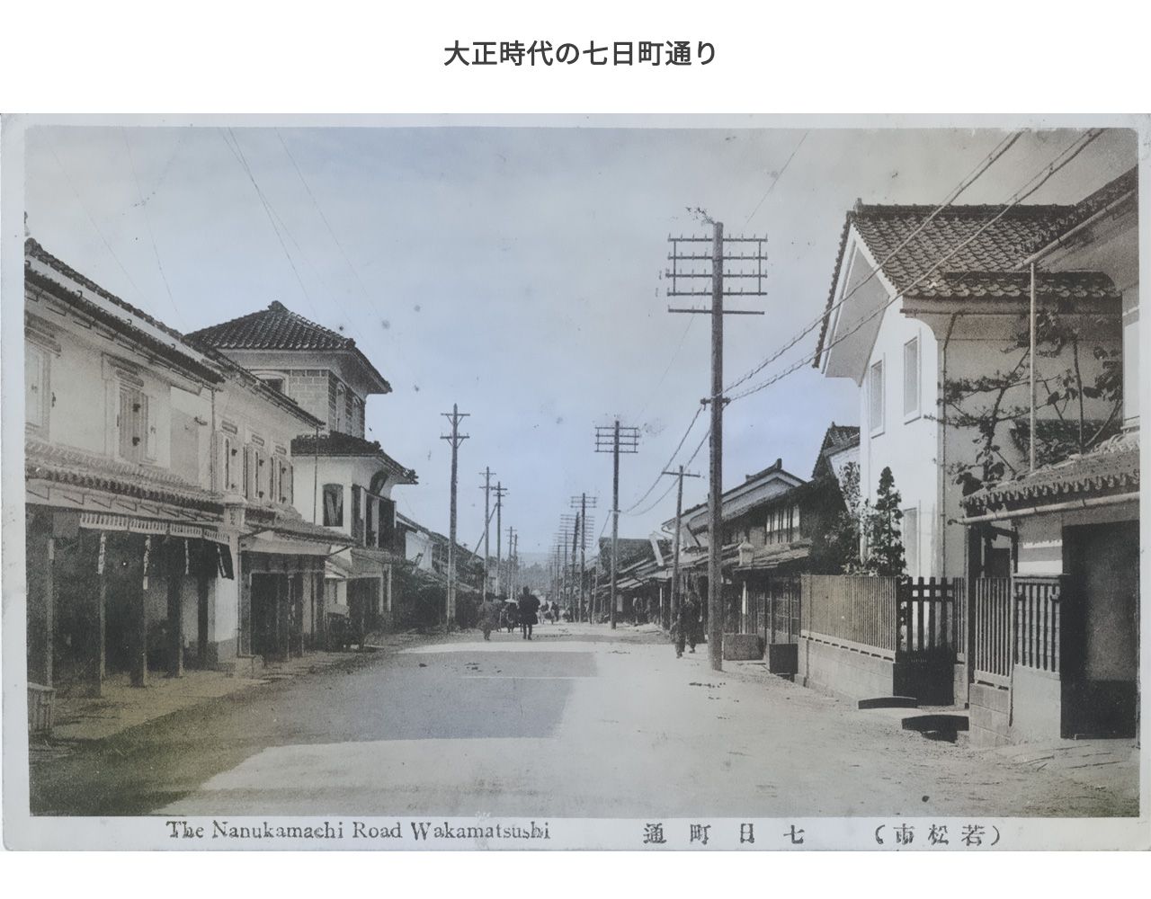 Nanukamachi-dori in the Taisho period. Looking west along the street from near Shirokiya Lacquerware Shop.
The three-story building visible on the left is Shimizuya Ryokan.
Colorized using deep learning
nanukamachi.com digital archive: Wakamatsu City Nanukamachi-dori
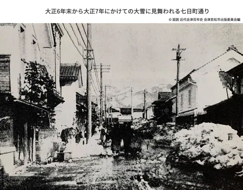
Nanukamachi-dori hit by heavy snowfall from late Taisho 6 to Taisho 7. The accumulated snow makes horse carriage passage difficult.
Select thumbnail images below to change the image.
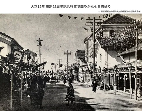
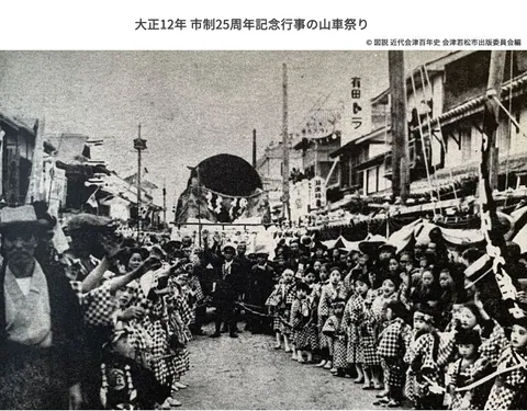
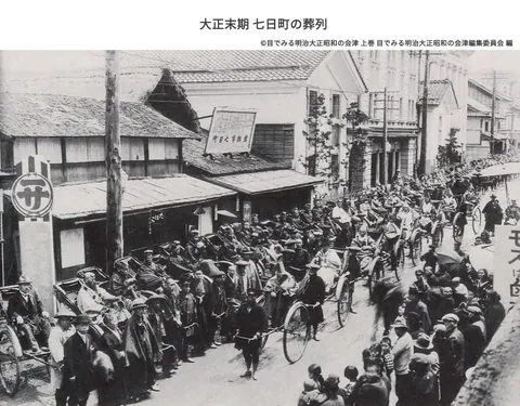
Previously, in Meiji 36 (1903), the Nanukamachi Post Office (whose first director was local sake brewer Naoichi Hayashi, who used part of his home as the office) had been established, but now private financial institutions also opened branches on Nanukamachi-dori.
In June Taisho 2 (1913), "Kangyo Chokin Kabushiki-gaisha" was established at Nanukamachi 13-banchi. In Taisho 10 (1921), "Taizo Chozo Bank" opened west of present-day Second Tsukahara Gofukuten, and next to it "Koriyama Hashimoto Bank Wakamatsu Branch" opened, with "Fukushima Prefecture Agricultural and Industrial Bank" beginning operations two shops further along.
On December 1, Taisho 11 (1922), "Koriyama Commercial Bank Wakamatsu Branch" began operations.
This era also saw the nationwide proliferation of small local banks.
However, the subsequent Showa Financial Crisis led to the consolidation of these banks. The Shimizuya Ryokan on Nanukamachi-dori was purchased by "Aizu Kangyo Mujin Kabushiki-gaisha" (predecessor of Daito Mutual Bank, now Daito Bank), which relocated its headquarters there. "Taizo Chozo Bank" changed its name to "Fukushima Chochiku Bank" and continued operations until being merged into Toho Bank. The site of "Koriyama Hashimoto Bank Wakamatsu Branch" saw "Daiyon Bank Wakamatsu Branch" relocate there, before it later moved to its present location.
Thus, the Taisho period, in which the townscape developed greatly, came to an end, and the era moved into Showa.
Townscape in the Prewar Showa PeriodThe prosperity of Nanukamachi-dori continued into the Showa period.
The following stores are recorded as operating at that time:
Lacquerware: Takase Kiemon, Fukunishi Soibe, Muto Shinkichi, Yamadera Kyukichi, Niinuma Inokichi
Sake brewing: Hayashi Heihachiro, Mafune Kyube
Marine products: Shibukawa Zentaro, Fujisaki Chukichi, Seki Kotaro
Others: Tsukahara Gofukuten, Second Tsukahara Gofukuten, Mihara Clock Shop, Hoshitoku Ceramics Shop
Furthermore, in this era, vehicles powered by engines such as automobiles, trucks, and motorcycles increased, and the atmosphere of the street began to change.
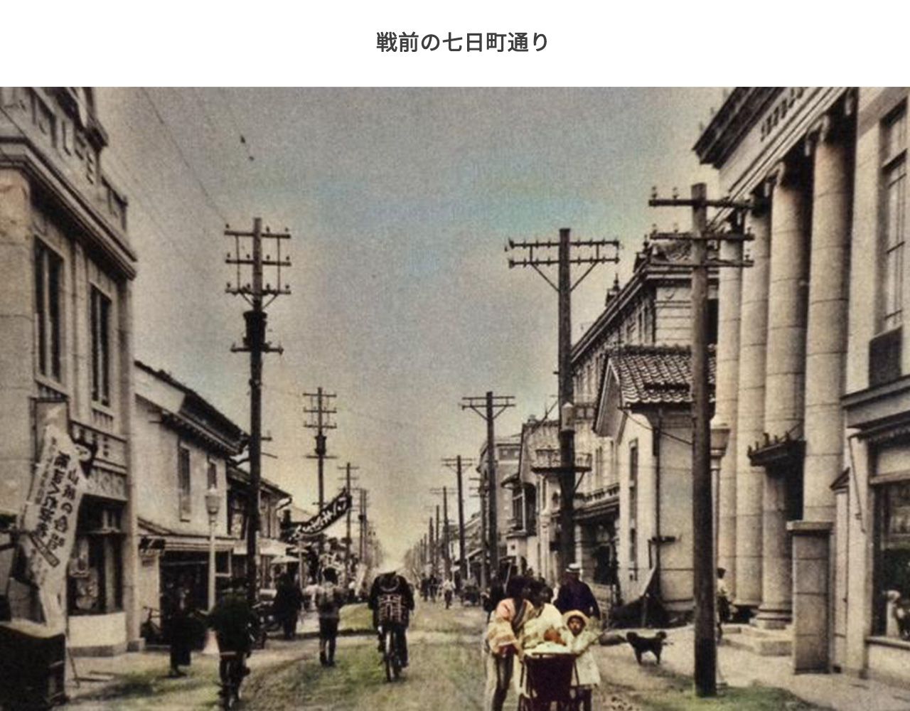 Nanukamachi-dori before the war.
The building with the large pillar visible on the near right, which still stands today, is the former Koriyama Hashimoto Bank Wakamatsu Branch (present-day Takiya Construction). Across the storehouse in the back, the building of Shirokiya Lacquerware Shop, which also still stands, can be seen.
People walking the street wear Japanese clothing, reflecting the era.
Colorized using deep learning
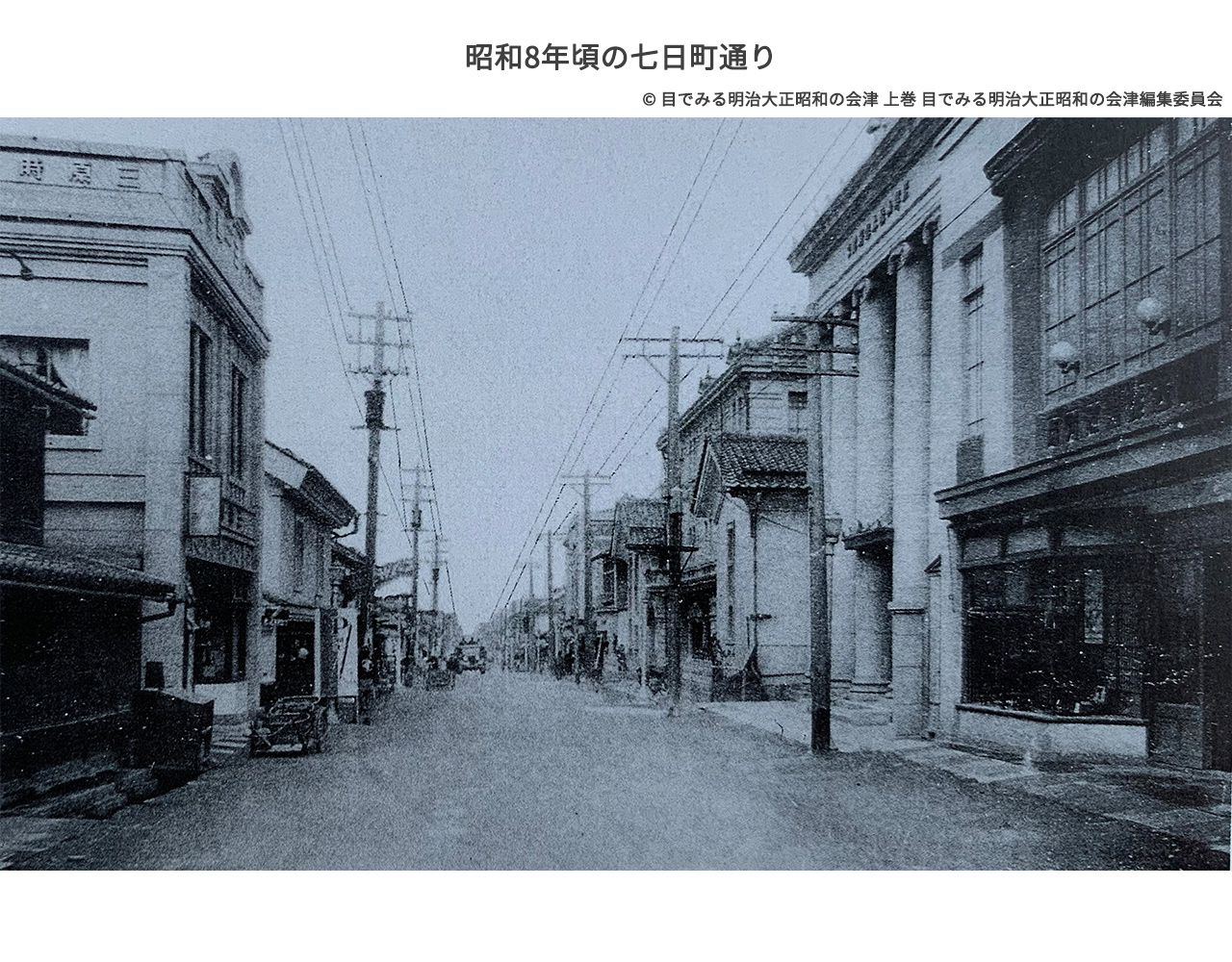 Nanukamachi-dori around Showa 8 (1933). On the left, Mihara Clock Shop has been newly built. A truck can be seen in the distance. Traffic volume is low, and the atmosphere remains leisurely.
Colorized using deep learning
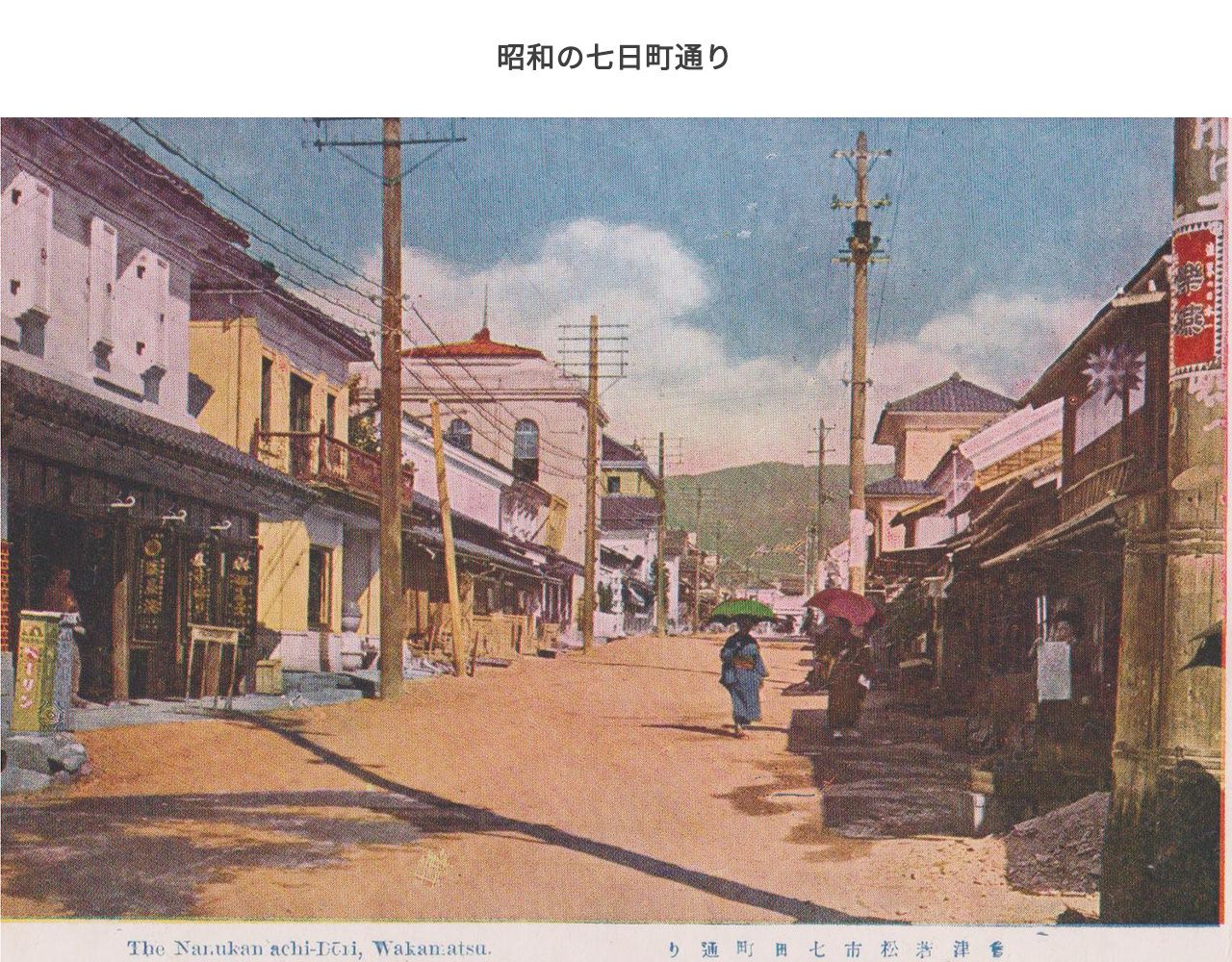 Nanukamachi-dori in the Showa period. A photograph showing the slope of the street. This location still has a noticeable incline that can be felt when walking.
nanukamachi.com digital archive: Aizu Historical Sites Iimoriyama Byakkotai Famous Scenes Eight Views in Color
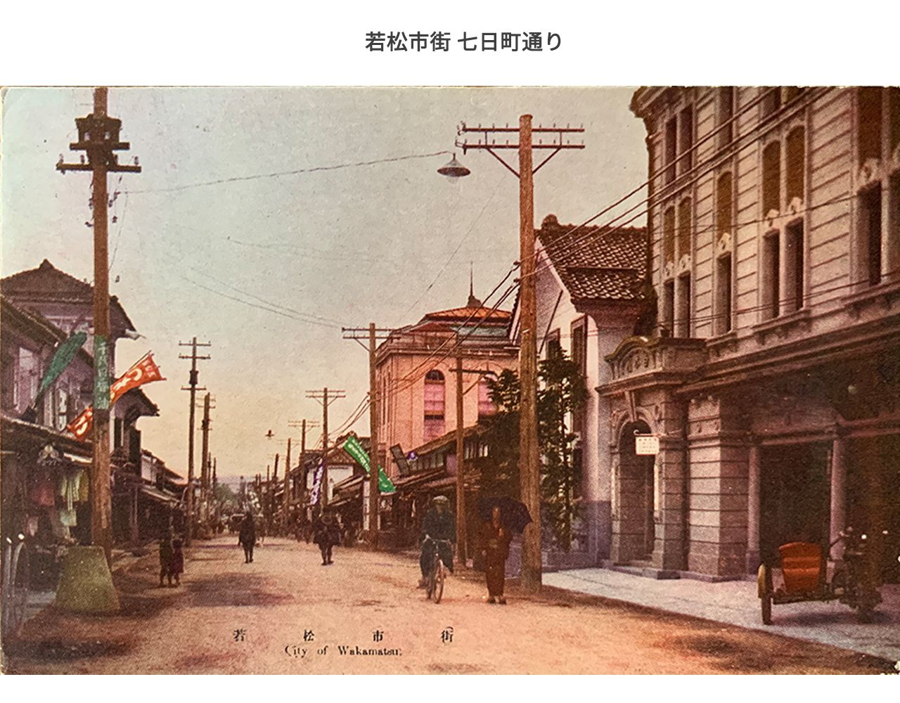 From picture postcards hand-colored based on black and white photographs and printed in offset.
The colors of shop banners, utility pole signs, and motorcycle sidecars can be seen.
On the near right is Shirokiya Lacquerware Shop, the same wall color as today. Across the storehouse, Second Tsukahara Gofukuten has different window configurations than today.
On the left, the building of Shimizuya Ryokan, now a former site, can be seen. Streetlamps have been newly hung from utility poles.
nanukamachi.com digital archive: Wakamatsu City Streets
In Showa 12 (1937), the road on Nanukamachi-dori was paved.
Thus, through the Meiji, Taisho, and pre-war Showa periods, as eras changed, Nanukamachi continued to play a major role as the center of economy and transportation.
Postwar Showa and Heisei: Decline and Revival of the StreetWith the end of World War II, the sounds of reconstruction grew along Nanukamachi-dori.In Showa 23 (1948), Nanukamachi Station was newly established. Establishing Nanukamachi Station on the short section between Aizuwakamatsu Station and Nishi-Wakamatsu Station involved great difficulty, but it was achieved through the enthusiasm of local residents.
Due to the National Comprehensive Development Act enforced in Showa 25 (1950) and the influence of the Korean War, as hydroelectric power development on the Tadami River accelerated to boost the Japanese economy, Nanukamachi-dori experienced feverish prosperity as the transportation gateway to construction sites.
(nanukamachi.com digital archive: Tadami River Hydroelectric Power Development)
(nanukamachi.com digital archive: Hydraulic Research Laboratory Okutadami 1,370,000KW Turbine Completion Commemorative Tokyo Shibaura Electric Co., Ltd. Turbine Division)
However, by the 1950s, with the completion of construction, the prosperity of Nanukamachi-dori began to wane.
Furthermore, as the era shifted from Showa reconstruction to the new Heisei, transportation conditions also changed.
Not only in Nanukamachi, but people's means of transportation shifted to automobiles. With the opening of bypass roads in the suburbs, the flow of people changed, and Nanukamachi-dori became simply a road, with many people passing through by car.
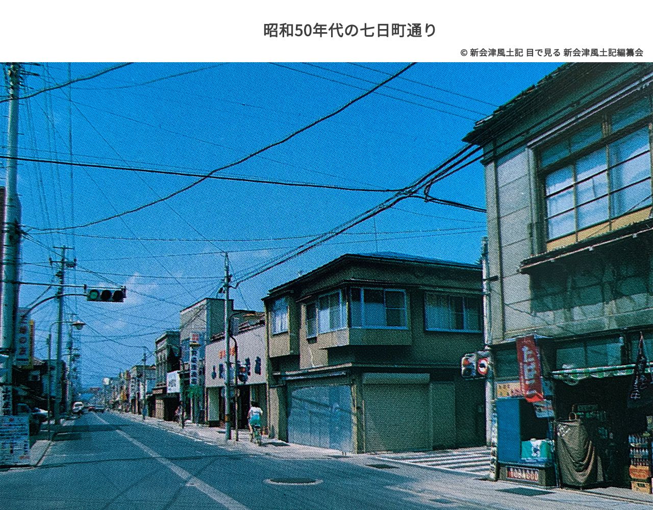 Nanukamachi-dori in the 1970s. Photographed looking west (toward Nanukamachi Station) from near the intersection of Nanukamachi-dori and Yamato-cho-dori (37.499521,139.924246). Building exteriors are not unified, and it has the atmosphere of a typical shopping street.
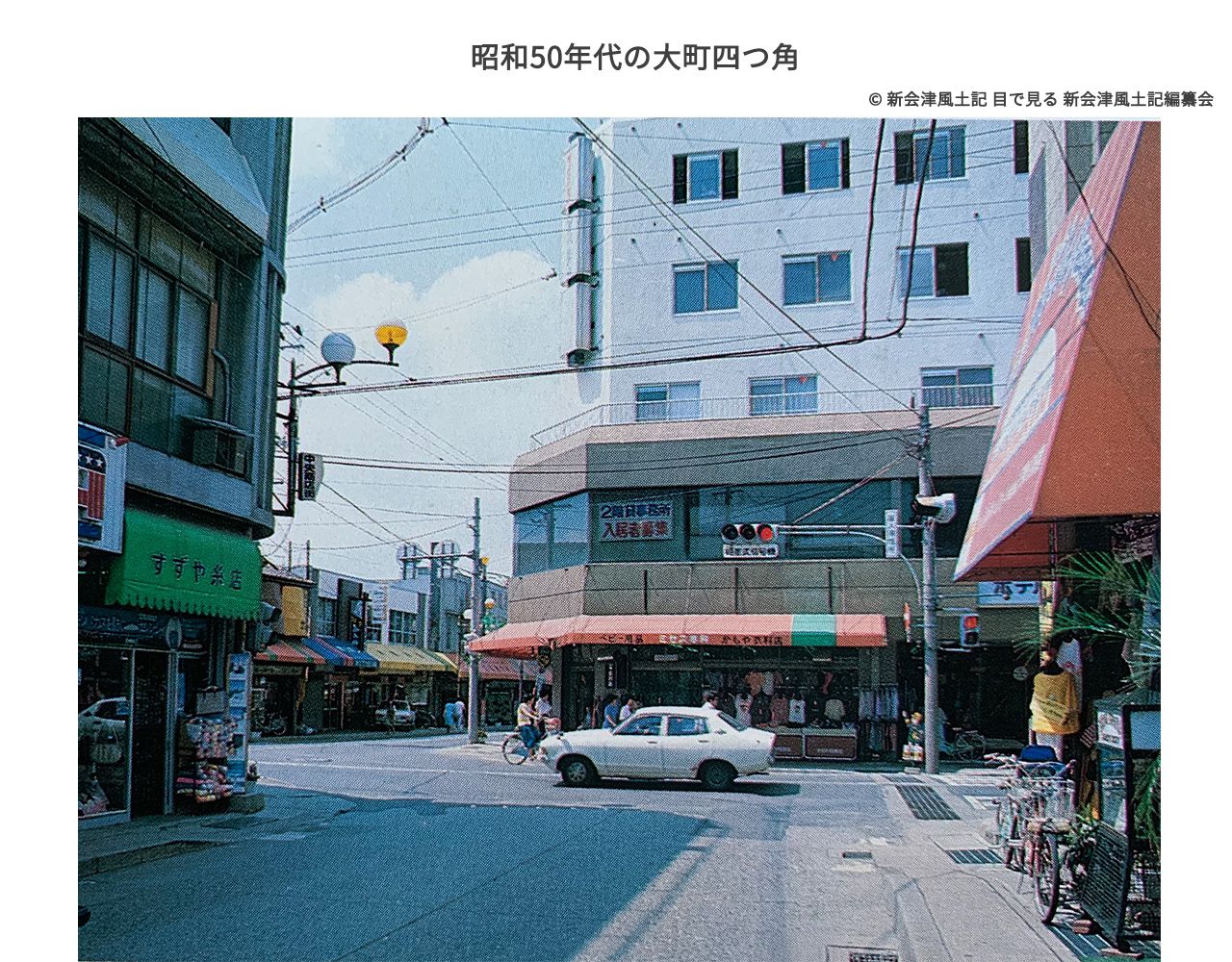 Omachi Yotsukado in the 1970s. Photographed looking west toward Nanukamachi-dori. The shapes of the cars evoke the era.
The street, once bustling with many people, saw pedestrians disappear and shops close their shutters by the 1990s and 2000s, becoming a desolate thoroughfare. Population decline and the aging of shop owners led to increasing vacancies, to the point where the Nanukamachi merchants' association dissolved.
To break this situation and restore the former vibrancy, three people stood up: Mr. Haruo Shibukawa (Director of Shibukawa Donya), chairman of the Nanukamachi-dori Townscape Council; Mr. Yutaka Shoji, vice chairman; and Mr. Shozo Meguro, chairman of the Aizuwakamatsu City Council. These three put into practice the idea that "since the town's population decline cannot be stopped, we will restore vibrancy by attracting tourists."
To that end, they renovated vacant stores, transforming them with retro designs and exteriors that harmonized with the townscape.
They also proposed actively showcasing buildings that had survived from earlier eras (removing exterior panels and signs added in modern times), making use of the existing heritage.
Not everything proceeded smoothly.
It seems it was not easy to persuade shop owners, who were, in a sense, weary from previous town revitalization failures. Many expressed opinions that the hollowing out of the old city center was inevitable and that this would be wasted effort.
However, when one shop was renovated and featured in guidebooks, attracting tourists, a successful model case emerged.
Furthermore, active provision of subsidies accelerated store renovations and landscape improvement.
As shops were renovated and tourists gathered, the renovation of Nanukamachi Station, a symbolic presence on the street, was also realized.Until then an unstaffed station in decline, Nanukamachi Station was renovated, and not only its appearance but also a station antenna shop was established.This transformed the station into a place where people gather.
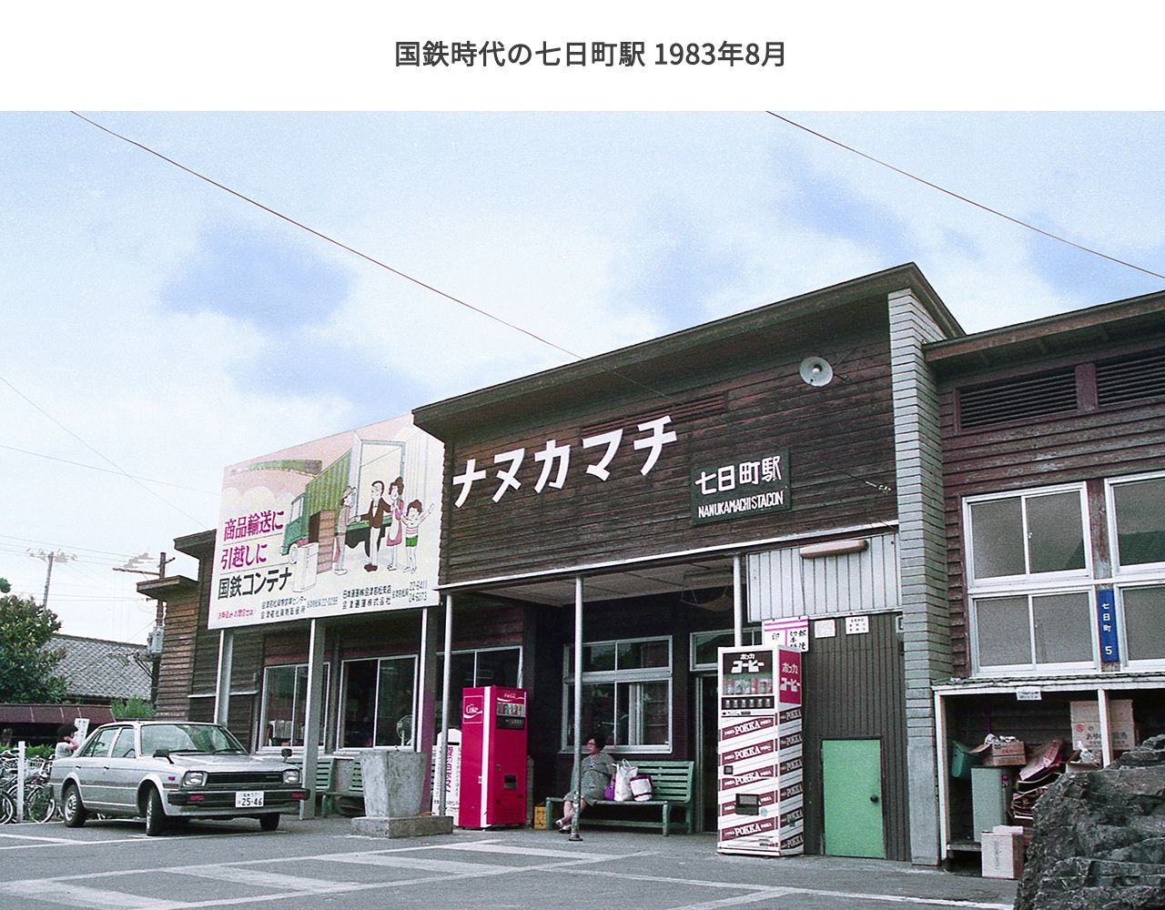 Nanukamachi Station in the JNR era. Photographed in August 1983. The large "Nanukamachi" sign is striking.
In addition to the increasing number of shops attracting people, regular events also began to be held.Events enabled regular customer attraction, and tourists visiting for the events also increased.Furthermore, the trend of increasing not only domestic but also overseas tourists continues.
Recently, renovation of large stores that can house multiple tenants has been progressing.All make effective use of storehouses and buildings of long-established merchant houses, aiming for operations suited to the times while preserving valuable architecture.Furthermore, the town as a whole has advanced in town planning that considers the landscape, such as putting power lines underground.
On the other hand, challenges remain.For example, some say the townscape lacks distinctiveness, making it difficult to form an image of "this is Nanukamachi-dori." Also, with several vacant stores still existing, how to utilize them remains a challenge. Furthermore, since Nanukamachi-dori is also an active road connecting the center to the suburbs, it is necessary to further enhance safety for pedestrians walking the town. And the lack of free parking lots for tourists, as well as the unavailability of free parking lots during winter, is also a challenge.
Thus, the vibrancy of Nanukamachi-dori has been preserved by people of each era.
The townscape, like a living thing, continues to change. Why not walk through Nanukamachi-dori, full of vitality even now, through the long passage of time?
TimelineThe Path of Nanukamachi-dori Revival in Modern Times
-
Heisei 5 (1993)
Participated in the National Townscape Seminar held in Kawagoe City. Shibukawa, Shoji, and Meguro surveyed the buildings of Nanukamachi-dori. As a result, approximately 10 Western-style buildings, 50 storehouses, and 20 merchant houses were confirmed to remain.
-
Heisei 6 (1994)
The Nanukamachi Townscape Council was established with 23 founding members. Selected for the Ministry of Land, Infrastructure, Transport and Tourism's Townscape Design Promotion Project and received funding. As a result, attention turned to historical and tourism resources that had previously gone unnoticed, such as O-mikura, the Eastern Army Cemetery, and Hajime Saito's grave.
-
Heisei 7 (1995)
Nanukamachi-dori was divided into three blocks (upper district, middle district, lower district), and a landscape town planning agreement was concluded with Aizuwakamatsu City. This made available a subsidy covering half of exterior construction costs, up to a maximum of 700,000 yen.
-
Heisei 8 (1996)
The brick street was developed by Aizuwakamatsu City.
-
Heisei 9 (1997)
Fukushima Prefecture and Aizuwakamatsu City purchased the site of a closed gas station and developed it as a citizen's plaza with a stage.
-
Heisei 14 (2002)
Fukushima Prefecture, Nanukamachi-dori Townscape Council, and JR East collaborated to renovate Nanukamachi Station building into a Taisho Roman-style Western building, with an adjacent station cafe. Aizuwakamatsu City developed the Nanukamachi Roman Koji (road in front of Aizu Brand Kan). Machizukuri Aizu, certified as a town management organization, opened Aibasse.
-
Heisei 16 (2004)
With support from Fukushima Prefecture, the Nanukamachi Townscape Council took the lead in establishing Aizu Brand Kan.
-
Heisei 22 (2010)
Received the Ministry of Land, Infrastructure, Transport and Tourism Urban Landscape Award, Excellent Beautiful Townscape Award.
-
Reiwa 1 (2019)
Received the Ministry of Land, Infrastructure, Transport and Tourism Tezukuri Kyodo Award, Grand Prize.
-
Reiwa 3 (2021)
Received the Fukushima Prefecture 6th Fukushima Industry Award, Special Prize.
-
Reiwa 5 (2023)
Received the Fukushima Prefecture 6th Fukushima Industry Award, Special Prize.
-
Reiwa 5 (2023)
Certified under the Historical Atmosphere Maintenance and Improvement Plan certified by the Ministers of Education, Culture, Sports, Science and Technology, Agriculture, Forestry and Fisheries, and Land, Infrastructure, Transport and Tourism. The "Policy on Historical Townscape and Landscape" formulated by Aizuwakamatsu City includes the underground power line plan for Nanukamachi-dori (National Route 252).
List of Sources Referenced in This Article
- Origin of Town Names: Mini History of Our Town, Former Town Names/Place Name Origin Booklet Publishing Committee, ed. Aizuwakamatsu City Board of Education (1986)
- Fukushima Prefectural Museum Survey Report 19, Fukushima Prefectural Museum (1989)
- 40-Year History of Daito Mutual Bank, Daito Mutual Bank (1983) info:ndljp/pid/964388